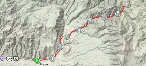
Above is a terrain map of Inman Canyon near Inkom, Idaho (courtesy Google and MapMyRide.com). The path starts on Inman Road off of Rapid Creek Road and then it turns into a dirt jeep trail that goes up to about 6600 feet in elevation up the Portneuf Range, the same range that contains Bonneville Peak and the Pebble Creek Ski Area. About a month ago, Travis and I checked this trail out a little. I was trying out some slick 38 mm wide tires at the time, and they handled ok on the trail, but I missed the stability and traction of my knobby 2 inch wide mountain bike tires.
 On Sunday, September 7, I decided to put my knobbies back on my mountain bike and explore this canyon. I took 3 liters of hydration and my regular supply of granola bars, spare tubes, and tools and headed off to Inkom. I pulled into the same park in Inkom that I always visit on these trips to top off my water supply and there was a couple of 40s-ish women on road bikes who obviously do the same thing. We chatted for a bit and then headed off to our destinations.
I made my way up Rapid Creek Road then right onto Inman road and soon the road turned into trail. The loose dirt and rocks on this trail made me thankful I put on my mountain bike tires. I had to pull off to the side of the trail about 5 times during this trip to let ATVs and pickup trucks go by. On my way up, I stopped at a small pull off and took some photos of a near-by stream and said hi to a mountain biker and another guy who was looking for a good place to shoot. My water supply was getting rather low so I knew that I had better just try to make it to the apex of this trail and then head home.
 Next, the trail began getting pretty dang steep; I had to hop off and hike-a-bike a couple times because I was so pooped. Finally, the trail opened up into a clearing and forked off down the opposite side and south side of the mountain. Later, I identified this location as Inman Pass and the two trails lead to Chesterfield and Lava Hot Springs. I desparately want to pack more supplies sometime and cycle to both! However, that would certainly turn into a multi-day cycling trip in order to get back all the way to Pocatello. This certainly underlines the fact that 100 miles on flat asphalt and 100 miles on a mountainous trail are two completely different things ;-) Photo gallery is here.


Leave a Reply